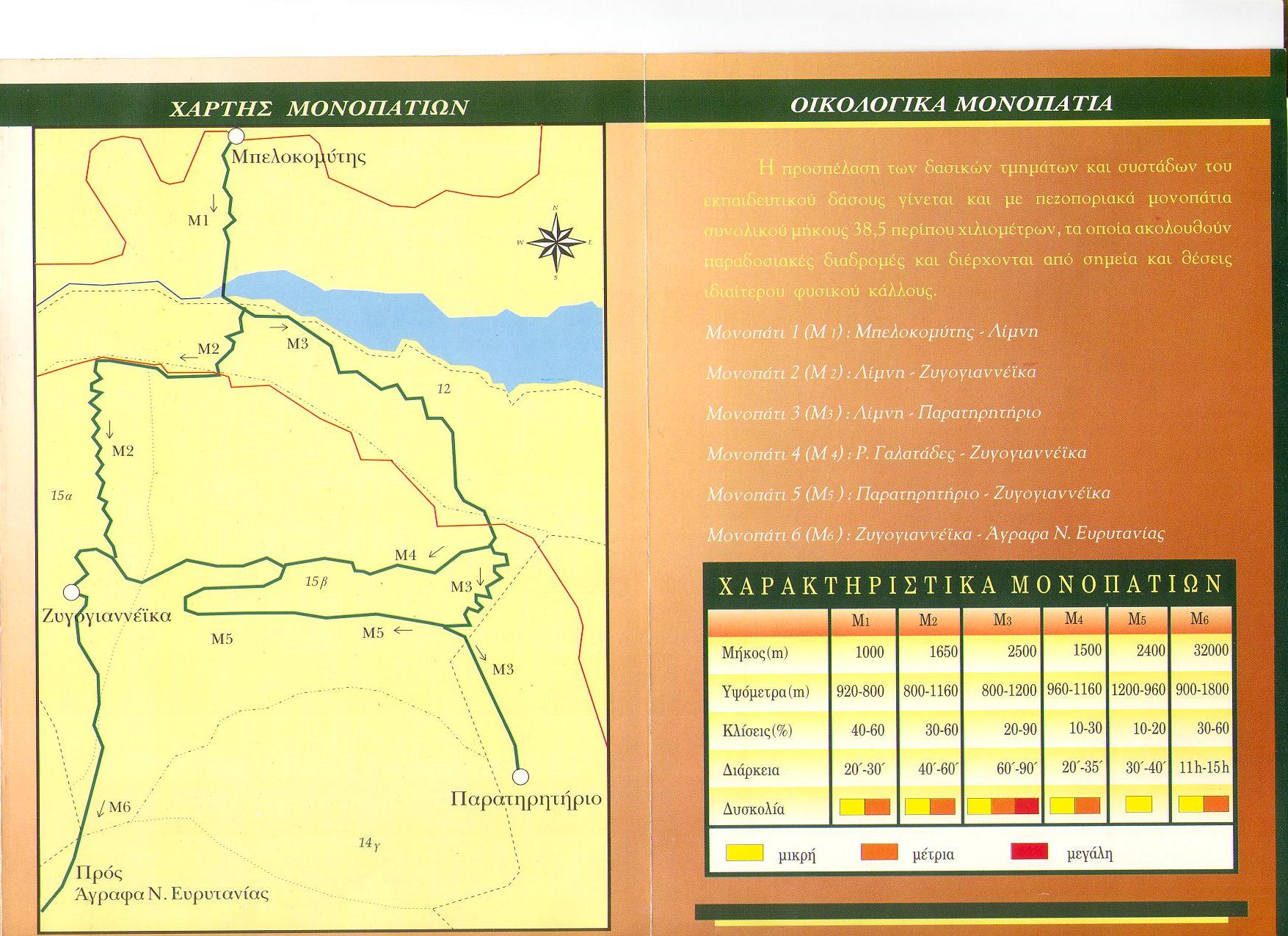
The beautiful mountains provide hiking trails and paths for all levels of difficulty. There are also lodges to accommodate hikers. The lodge of Agrafa in the Karamanoli site and the lodge Elatos in the forest of Belokomitis are the bases of operation for hikers en route to Borlero (2,016m), Voutsikaki (2,154m) and other Agrafa summits.
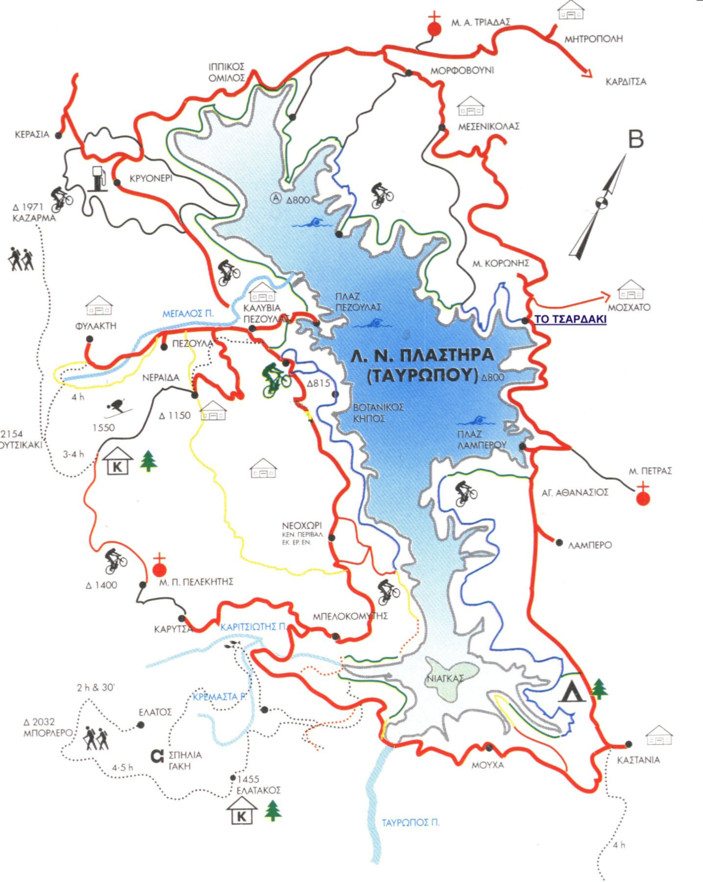
There are also various trails that start from different locations, initiated by hiking clubs and individual hikers, of varied lengths and levels of difficulty. Whether you hike individually or in a group, you will experience an amazing landscape and breathtaking views of the lake.
The entire region of the Municipality of Plastiras Lake offers excellent opportunities to experience nature through amazing hiking and climbing trails. The existing paths are appropriately marked for safe hiking through dense, rich forests, with species that alternate depending on the altitude, a rich fauna, and exceptional views. The basic trails available for hiking are listed below, including information to help you choose.
| Route | code | elevation (m) start / end |
elevation difference |
length (km) | |
|---|---|---|---|---|---|
| 1 | Kalivia of Pezoula – Neraida – Karamanoli Lodge (junction with path Β1) | B3 | 903/1520 | 617 | 4.5 |
| 2 | Neochori – Agia Paraskevi – Karamanoli Lodge | B1 | 995/1520 | 525 | 4.5 |
| 3 | Kerasia – Mantania – Prophet Elias of Kerasia | B15 | 860/930 | 70 | 3.5 |
| 4 | Filakti – Milareika – Ai-Elias – Apelina | B14 | 1102/1439 | 367 | 2.3 + 1.3 |
| 5 | Moschato (stone bridge) – Tsardaki | H9 | 344/795 | 451 | 2.9 |
| 6 | Alepotripes – Halikaki (Mosxato) | H10 | 697/825 | 128 | 0.4 |
| 7 | Morfovouni (Kontostergeika) – Vrises Ai-Giorgi | H8 | 738/517 | 221 | 1.8 |
| TOTAL | 21.2 |
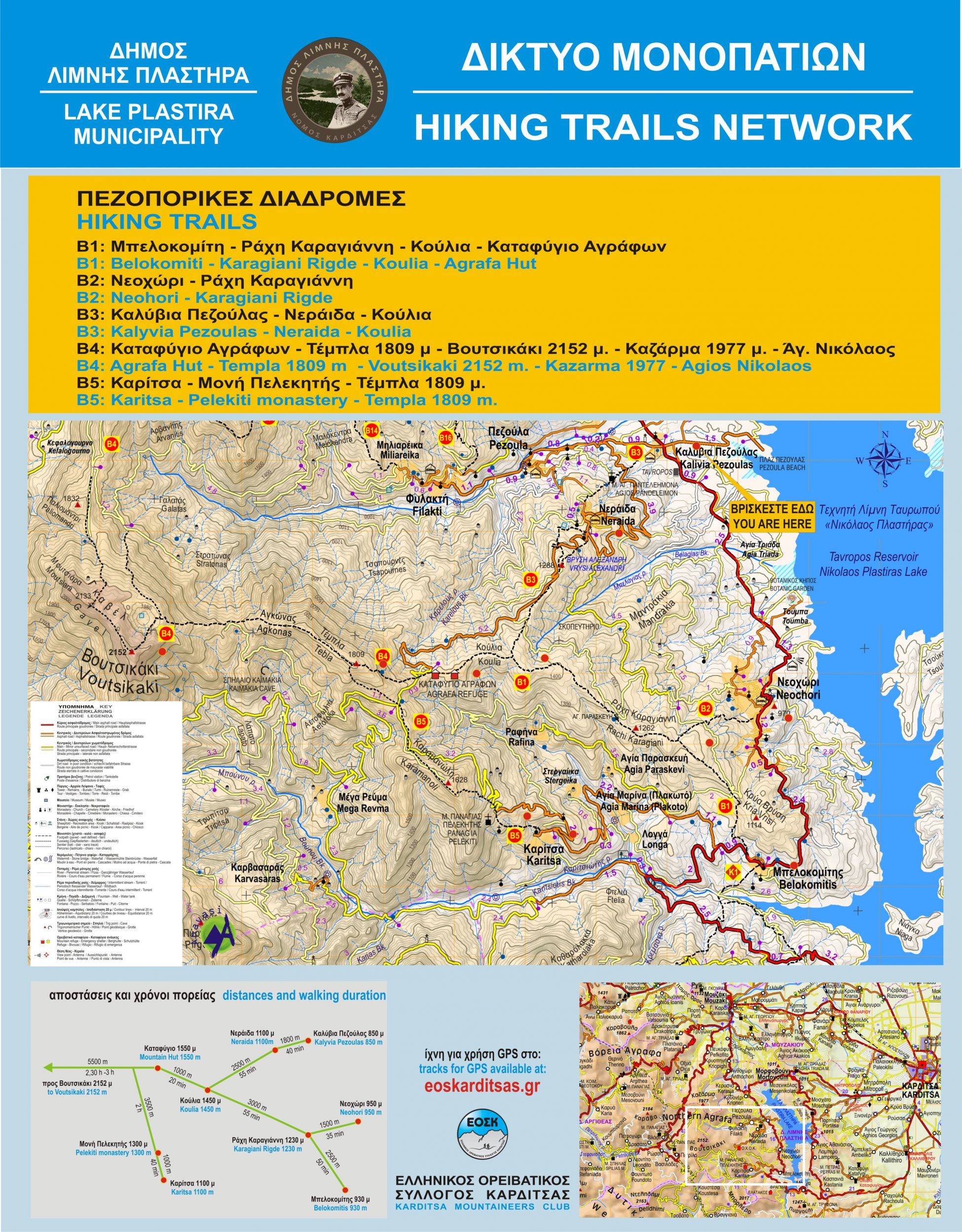
1. Trail B3: Kalivia of Pezoula – Neraida – Karamanoli Lodge (junction with trail B1)
The trail begins from the village Kalivia of Pezoula and follows the path of Agios Panteleimon where there is a recreation area. Then it climbs to Neraida village, covering a distance of 1,700 meters. If you follow the trail past Neraida through the “Koulia” site, you come across trail B1 that leads to the Karamanoli mountain lodge. Its total length is 4,500 meters, requiring an 1.5-hour hike. At the beginning of the trail, located at the junction with the rural road that leads to Neraida, stone stairs with wooden fencing will be constructed.
- Trail length: 4,500 meters
- Trail type: Hiking
- Average hiking time: 1.5 hours, approx.
- Difference in elevation: 617 meters
- Difficulty: Moderate
- Amenities: Recreation area
2. Trail B1: Neochori – Agia Paraskevi – Karamanoli Lodge
This trail is a part of the larger B2 trail that begins at Belokomitis.
The trail begins at Neochori and after a 40-minute hike it ends at the chapel of Agia Paraskevi, where a recreation area with picnic tables will be constructed. Then the trail goes through a fir forest (at “Koulia”) and ends at the Karamanolis Lodge, with a view of Lake Plastiras and the surrounding summits. Its total length is 4,500 meters and it requires a 1.5-hour hike. At the beginning of the trail a paved road with wooden fencing will be constructed.
- Trail length: 4,500 meters
- Trail type: Hiking
- Average hiking time: 1.5 hours, approx.
- Difference in elevation: 525 meters
- Difficulty: Moderate
3. Trail B15: Kerasia – Mandania – Prophet Elias of Kerasia
The trail includes the route from the junction of the Kerasiotis river and the rural road towards the Community of Kerasia. After covering a distance of about 1,100m. by the river with the sycamore ecosystem, it reaches the Mandania site. Continuing north, the trail reaches Prophet Elias. The route passes through alternating landscapes of meadows and forests, offering hikers spectacular views. Its total length is 3,500 meters and it requires a 1-hour hike. At the beginning of the path, on the section along the river, a stone-paved road will be constructed.
- Trail length: 3,500 meters
- Trail type: Hiking
- Average hiking time: 1 hour
- Difference in elevation: 70 meters
- Difficulty: Low
- Principal vegetation: Riverside sycamore ecosystem
4. Trail B14: Filakti – Milareika – Ai-Elias – Apelina
The route begins from the village square of the Community of Filakti, and follows the road to the “Milareika” site, and then the existing path until the “Kassandra” spring, where there is a recreation area. A 50-m paved road and wooden fencing will also be constructed. Next, the trail passes through dense stands of fir and ends at the chapel of Ai-Elias, offering a unique view of the lake. Its total length is 2,300 meters and it requires a 45-minute hike. A path (with cobblestones and wooden fence) will also begin from the village of Filakti and after a distance of 1,300m will lead to the “Apelina” site, where a recreation area with picnic tables will be constructed. Alternatively, hikers can reach “Apelina” from Ai-Elias through the forest road, taking a circular route.
- Trail length: 2,300 meters
- Trail type: Hiking
- Average hiking time: 45 minutes, approx.
- Difference in elevation: 367 meters
- Difficulty: Low
- Amenities provided: Recreation area in the forest
5. Trail H9: Moschato (stone bridge) – Monastery of Korona – Tsardaki
The trail begins from the stone bridge located on the road to Moschato near the village, where a 100m cobble stoned path with wooden fencing will be constructed. Then the trail passes above the village of Moschato (near the stadium), it passes the village of Rahitsa and then it reaches the “Tsardakovrisi” site, where there is a recreation area. Hikers can also visit the Monastery of Korona, a distance of 600m. on the existing asphalt road. The trail then leads to the “Tsardaki” site on the shore of Lake Plastira. Its total length is 2,900 meters and it requires a 45-minute hike.
- Trail length: 2,900 meters
- Trail type: Hiking
- Average hiking time: 45 minutes
- Difference in elevation: 451 meters
- Degree of difficulty: Moderate
- Amenities provided: Recreation area, halfway
6. Trail H10: Alepotripes – Halikaki (Moschato)
The trail starts from the rural road from Moschato to Tsardaki, at the “Alepotripes” site in the village, where stone steps with wooden fencing will be constructed. After a short hike of about 400m through an oak forest, it leads to the “Halikaki” site, where a recreation area will be constructed. Alternatively, hikers can go from “Halikaki” to “Tsardaki” through the forest road, coming across the H9 trail.
- Trail length: 400 meters
- Trail type: Hiking
- Difference in elevation: 128 meters
- Difficulty: Low
- Principal Vegetation: Oak Forest
7. Trail H8: Morfovouni (Kontostergeika) – Vrises of Ai-Giorgi
The trail starts from the village of Morfovouni, where a cobble stoned path with wooden fencing will be constructed. After passing through a forest with broad leaf trees, it reaches the “Vrises of Ai-Giorgi” site where a recreation area with picnic tables will be constructed. Its total length is approx. 1,800m, and it requires a 30-minute hike.
- Trail length: 1,800 meters
- Trail type: Hiking
- Average hiking time: 30 minutes, approx.
- Difference in elevation: 221 meters
- Difficulty: Moderate
- Principal Vegetation: Broad leaf Forest
8. Agrafa Mountain Lodge – Cave of Gakis
- Trail length: 7,850 meters
- Trail type: Descent most of the way
- Average hiking time: 3 hours
- Difference in elevation: From 1450m to 1100m
- Difficulty level: Low to Moderate
- Amenities provided: Trail markings, pavilion, water, picnic tables
- Principal Vegetation: Dense fir forest, riverside forest
- Interesting natural formations: Karitsiotis River, Kerendan River Gorge
9. Agrafa Mountain Lodge – Agios Nikolaos at Petrilo
- Trail length: 12,200 meters
- Trail type: 5,500m ascent , 6,700m descent
- Average hiking time: 5 hours
- Difference in elevation: From 1450m to 2152m
- Difficulty: Moderate to High
- Amenities provided: Trail markings, pavilion, picnic tables
- Principal Vegetation: Fir forest, sub-alpine meadows
10. Agrafa Mountain Lodge – Filakti
- Trail length: 7,340 meters
- Trail type: Lodge-Neraida-Pezoula : descent ; Pezoula-Filakti: ascent
- Average hiking time: 1 hour 20′
- Difference in elevation: From 1450m to 970m
- Degree of difficulty: Moderate
- Amenities provided: Trail markings, pavilions, picnic tables, water
- Principal Vegetation: Dense fir forest/ Mixed fir and oak forest
11. Filakti – Gavel (Voutsikaki summit)
- Trail length: 10,410 meters
- Trail type: Ascent
- Average hiking time: 3 hours
- Difference in elevation: From 970m to 2152m
- Difficulty: High
- Amenities provided: Trail markings, pavilions, picnic tables, water
- Principal Vegetation: Fir forest, sub-alpine meadows